


D3 Customs
10" Tread® XL - Baja Race Edition - SxS GPS
10" Tread® XL - Baja Race Edition - SxS GPS
Couldn't load pickup availability
PART NUMBER:010-02510-00
BUILT TO NAVIGATE THE UNFORGIVING AND SUPPORT YOUR RACE VEHICLE
Built for high performance and high speed competition, this off-road rugged Race GPS navigator has all the tools you will need to stay on the track, and the advanced communication tech to keep in connection with global satellite coverage. With the Tread XL - Baja Race Edition, you can stay in touch with your chase vehicle is at all times, and be able to easily communicate and always depend on your race team if any problems or challenges pop up or if you need to coordinate emergency repairs.

TRACK YOUR TEAM
Track your Team with the Garmin built-in inReach technology. This will let you you see the live real time positions of your chase truck and race vehicle utilizing Garmin's global satellite coverage. Also, you can quickly and easily receive and send text messages to coordinate repairs through Satellite without cellular coverage. This feature requires active inReach Flex Team Subscription. Experience the power of integrated inReach technology, providing worldwide satellite communication capabilities, two-way text messaging, location sharing, and interactive SOS functionality.

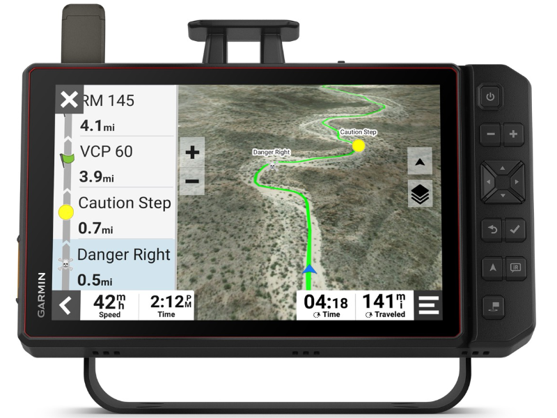
KNOW YOUR COURSE, GET DONE FASTER
Easily import any GPX data ahead of time to view the course start and end, generate a racetrack line, create virtual checkpoints, note race mile markers and pit locations.

PRERUN TOOLS
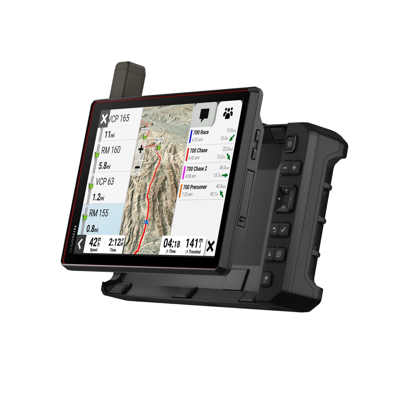
TRUCK TRACKING
When it's GAME TIME, and you are in race mode, switch the device to real-time track a chase vehicle on the map. Never loose track of your chase vehicle again and always be ready to respond.
TEAM TRACKING & PLANNING
Take full advantage of Garmin's cutting edge team tracking with unlimited SOS, text messages and more all without cellular service. (This feature does require an active inReach Flex Team Subscription)

HIGH-RES SATELLITE IMAGERY
Download high-resolution "BirdsEye Direct" satellite imagery to view enhanced overhead images of your surrounding area. Know where you are using geographical landmarks.


ALL-TERRAIN TOUGHNESS
Tread is purpose-built for all-terrain use, standing up to anything the elements can throw at it. It’s IP67-rated for dust and water-resistance and built to U.S. military standard 810 for thermal and shock resistance. Features a user-friendly 10” touchscreen display, operable with gloves.

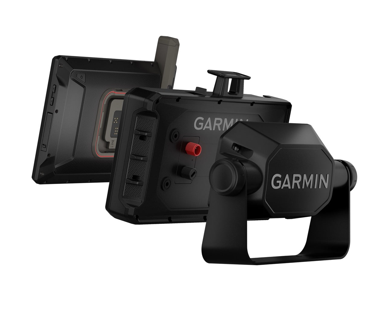
SECURE MOUNTING SOLUTION & PORTABILITY
Utilize the included heavy-duty suction cup and locking magnet-assisted mount to firmly attach the Baja Chase navigator to your vehicle, ensuring stability and peace of mind throughout your travels. Also allows for easy transfer between one chase truck to another.
SPECIFICATIONS:
| DIMENSION | 9.9"W x 7.8"H x 1.2"D (25.2 x 19.9 x 3.1 cm), device only 11.4"W x 7.6"H x 2.5"D (29 x 19.3 x 6.4 cm), device and dock |
| WEIGHT |
32.8 oz (930 g), device only |
| WATER RATING | IPX7 |
| DISPLAY TYPE | multi-touch, glass, high brightness HD color TFT with white backlight |
| DISPLAY SIZE | 8.5"W x 5.3"H (21.7 cm x 13.6 cm); 10.1" diagonal (25.7 cm) |
| DISPLAY RESOLUTION | 1280 x 800 pixels |
| DUAL-ORIENTATION DISPLAY | Yes |
| MAGNETIC MOUNT | locking magnet-assisted mount |
| MOUNT TYPE | bail mount |
| 1.5" BALL ADAPTER WITH AMPS PLATE | Yes |
| DROP RATING | MIL-STD-810 |
| DUST RATING | IP6X |
| BATTERY TYPE | rechargeable lithium-ion |
| BATTERY LIFE |
Up to 6 hours at 50% backlight |
| COMPATIBLE WITH TREAD XL BAJA DOCK ACCESSORY | yes (included) |
| Maps & Memory | |
|---|---|
| PRELOADED STREET MAPS | Yes |
| HIGH DEFINITION 3D TERRAIN | Yes |
| DATA CARDS | microSD™ card (not included) |
| 3D TERRAIN | Yes |
| INTERNAL STORAGE | 128 GB |
| ABILITY TO ADD MAPS | Yes |
| EXTERNAL MEMORY STORAGE | yes (256 GB max microSD™ card) |
| INCLUDES MAP UPDATES | Yes |
| DOWNLOADABLE SATELLITE IMAGERY | yes (BirdsEye) |
| BIRDSEYE DIRECT SATELLITE IMAGERY | Yes |
| Sensors | |
|---|---|
| GPS | Yes |
| GALILEO | Yes |
| BAROMETRIC ALTIMETER | Yes |
| COMPASS | Yes |
| 10 HZ MULTI-GNSS POSITIONING | Yes |
| Outdoor Recreation | |
|---|---|
| POINT-TO-POINT NAVIGATION | Yes |
| PRELOADED TOPOGRAPHICAL MAPS | Yes |
| PRELOADED US PUBLIC LAND BOUNDARIES | Yes |
| PRELOADED PRIVATE LAND PARCEL MAPS | yes (parcels greater than 4 acres) |
| PRELOADED USFS ROADS AND TRAILS, INCLUDING MOTOR-VEHICLE-USE-MAPS FOR MOTORCYCLE, ATV, SXS AND FULL-SIZE 4X4 | Yes |
| NAVIGATE-A-TRACK NAVIGATION | Yes |
| TURN-BY-TURN TRAIL NAVIGATION | Yes |
| Camera Features | |
|---|---|
| BACKUP CAMERA COMPATIBLE | yes (BC™ 50) |
| Advanced Features | |
|---|---|
| WI-FI® MAP AND SOFTWARE UPDATES | Yes |
| Adventure Features | |
|---|---|
| BUILT-IN INREACH® TECHNOLOGY (REQUIRES ACTIVE SUBSCRIPTION; SUBJECT TO REGULATIONS OR PROHIBITIONS IN SOME JURISDICTIONS) | Yes |
| PAIR WITH GARMIN POWERSWITCH™ DIGITAL SWITCH BOX | Yes |
| COMPATIBLE WITH GROUP RIDE RADIO | Yes |
| COMPATIBLE WITH EXTERNAL GPS ANTENNA WITH MOUNT | yes (included) |
| COMPATIBLE WITH EXTERNAL INREACH® SATELLITE ANTENNA | yes (included) |
| GROUP RIDE MOBILE | yes (with Garmin Tread app) |
| TRACK RECORDER (BREADCRUMBS) | Yes |
| IOVERLANDER™ POINTS OF INTEREST | Yes |
| ULTIMATE PUBLIC CAMPGROUNDS | Yes |
| BIRDSEYE SATELLITE IMAGERY (DOWNLOAD VIA WI-FI) | Yes |
| GLOVE-FRIENDLY TOUCHSCREEN | Yes |